Maps for Migrants
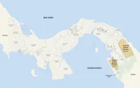
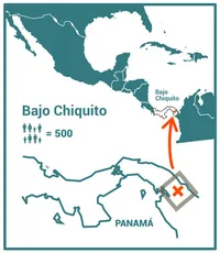
Between December 2023 and June 2024, we conducted research on migration in Panama through the Darién rainforest. My collective, Almanaque Azul, in association with indigenous mapping group GeoIndigena, was hired for this mission by the United Nations Development Programme (see credits below). From 2023 to 2024, we made several trips to the communities of Bajo Chiquito and Canaan in the Emberá-Wounaan Comarca (a Comarca is an indigenous autonomous province) to study the challenges they faced due to the extreme situation in which they found themselves, where thousands of people passed through their communities daily on their way to the United States.
In 2023, over half a million people crossed through what is known as the “Darién Gap”. Their first stop, after several days of walking through the jungle, was these two communities. The vast majority of those who passed through here were Venezuelans. It is a dangerous journey, but people do it because they are left with few other options. For example, the number of migrants doing the crossed surged when Mexico began requiring Venezuelans to have a visa to enter the country legally.
During the months we were working there, about 2,000 people arrived every day in Bajo Chiquito, and a few hundred fewer in Canaan. This greatly disrupted the lives of the people in these communities. The purpose of the work was to understand what was changing, what problems and opportunities the people there were facing, and also to document the relationships between the migrants and the locals. We interviewed dozens of migrants and humanitarian workers and held several meetings with the people of the community.
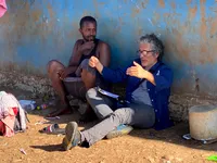
What we found was overwhelming humanity and solidarity from the communities in the Emberá-Wounaan Comarca and amongst migrants. We saw people who demonstrated great sensitivity to a very unique situation. Many children, families, and individuals were fed for free; we witnessed rescue teams being sent when people were stranded in the jungle, and in general, migrants were treated with great kindness.
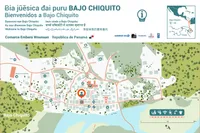
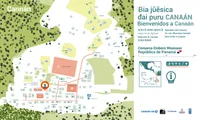
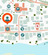
During the workshops with the people of Bajo Chiquito and Canaan, the idea came up to make a public map of the village. They wanted two things: for the migrants to know that they had arrived in the Emberá-Wounaan Comarca in Panama and to be able to orient themselves in the village and see where things were. The idea was to print the maps on large vinyl banner (3 m wide) and place them at the main square of each village.
I drew the base map using a drone composite ortho-photo taken by the colleagues from GeoIndigena. During one of the visits to the communities, walking with locals, we recorded the key spots, such as the health center, the dock where the migrants arrived, and the restaurants. With that information, I created a basic map that we later reviewed, corrected, and validated in a workshop with the community.
The welcome greeting on the map is in Emberá, the language spoken in Canaan and Bajo Chiquito; then there are the most common languages of the migrants: Spanish, Haitian Creole, Portuguese, Somali, Hindi, Pashto, English, and Simplified Chinese.
The map design, which was refined by our long-time collaborator Marilaura Cajar, was intended to work as much as possible non-verbally so that the information could more easily flow to people in a strange and difficult situation.
On the map of Bajo Chiquito, I followed the principle of placing the body of water at the bottom. I learned some time ago in my participatory cartography work that people living by the water (river, sea, or lake) find it more natural for the map to have the water at the bottom. This was true here as well.
Credits: Map by Mir Rodríguez Lombardo, with design by Marilaura Cajar. Base map ortho-photos by GeoIndigena. Community workshops led by Michelle Szejner. Almanaque Azul consists of Miriam Pons, Michelle Szejner, and Mir Rodríguez Lombardo.
Created under the initiative “Peaceful coexistence and social cohesion for local development of host communities in the Bajo Chiquito-Lajas Blancas and Canaán sections of the Emberá-Wounaan Comarca.” The creation of these maps has been made possible by the support provided by the United States Government through the United States Agency for International Development (USAID), and by the technical assistance of the United Nations Development Programme in Latin America and the Caribbean (UNDP). The opinions and views presented on this webpage are the sole responsibility of the author and do not necessarily reflect the opinions or views of the agencies and organizations that supported the creation of these maps, nor those of the member countries of the United Nations.
UNDP Panama Resident Representative: María Del Carmen Sacasa
UNDP Panama Deputy Resident Representative: Itziar González
UNDP Panama Team:
Patricia Pérez Prieto, Governance, Peace, and Human Rights Officer
Nelva Araúz Reyes, Gender Specialist
Anibal Cárdenas-Mosquera, Head of Solutions Mapping at the Accelerator Lab
Betty Chemier, Head of Experimentation at the Accelerator Lab
UNDP Infosegura Team:
Marcela Smutt, Regional Coordinator
Gerald Mora Muñoz, Deputy Regional Coordinator
Lyla Gil, Citizen Security Analyst
Gabriela Pérez García, Specialist in Justice and Rule of Law
GeoIndigena: Carlos Doviaza, Eliseo Quintero
Fundación Almanaque Azul: Michelle Szejner, Mir Rodríguez, Miriam Pons
- Paper
- Originally, 3 m × 1.8 m; finally, letter size
- For: Almanaque Azul
- Mir Rodríguez Lombardo with Almanaque Azul, May 2024
