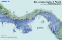
New map of Panama's watersheds
We are working on an project at Almanaque Azul to update information about community-based organizations (CBOs) throughout Panama. From here came a question: Which basin do you belong to? In other words: What are your waters?
The basins and sub-basins where we live, work and play are the most important polygons of our political life, I think. They are (or should be) much more relevant and real than the countries, provinces or states where we live. This map is a draft to help us know where we are.
Las cuencas y las subcuencas donde vivimos, trabajamos y jugamos son los polígonos más importantes de nuestra vida política, pienso yo. Son (o deberían ser) mucho más relevantes y reales que los países, las provincias o los estados donde vivimos. Este mapa es un borrador para ayudarnos a saber dónde estamos.
The map is still in draft and there are several errors corrected. It is based on data from HydroSHEDS, which has been heavily edited due to its low precision at the scale of this map (the HydroSHEDS website announced that v2 of this dataset will be released soon). The visualization is similar to that of the Pacific map, i.e. vector shading using the slope and aspect of each sub-basin to calculate the color of each of these watershed polygons.
- Digital
- For: Almanaque Azul
- Mir Rodríguez Lombardo, May 2024
