Abya Yala
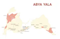
The commission of the Revista de la Universidad de México for its April 2019 edition called Abya Yala forced me to question some of the rules of cartography. Maps as we know them today have their origin with the need for navigation charts to cross the seas and to declare ownership over other people’s lands, i.e. colonialism. The name America comes from a cartographer of those times, part of the colonial machinery. Abya Yala is the way many indigenous peoples of this continent have decided to call it.
One of these cartographic norms is the convention of putting the north at the top of the map. When I freed myself of that obligation, I had to ask how and why to orient Abya Yala. The result has three motivations. The most important for me is to subvert the latitudinal hierarchies of a continental mass placed vertically, where what is below seems less important than what is above. That is one of the advantages of the European map, that everyone is more or less at the same level. Additionally, the map was printed on dual-page spread and this position was the best way to use the available space. Finally, I do believe that the continent looks much nicer lying down. After looking at it a lot, I got used to it and later made several more maps with similar orientations.
The territories shown on the map are those that appear in the issue of the magazine. The projection is Mollweide, an equal-area projection, with its center at the -90 meridian.
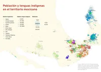
In that same issue I published a map on the indigenous population in Mexico and the number of speakers of native languages in those places. It is important to understand what is happening with indigenous languages in Mexico, because they are disappearing. As the Mixe linguist Yásnaya Aguilar said in front of the congress of this country, “Our languages do not die, they are killed. The Mexican State has erased them with its idea of a single way of thinking, a single culture, a single State”.
- 37 cm × 26.5 cm
- For: Revista de la Universidad de México
- Mir Rodríguez Lombardo, April 2019

